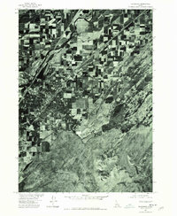
1974 Map of Blackfoot
USGS Topo · Published 1975About this map
Snake River dominates the western edge of this 1974 orthophotograph, where the agricultural geometry of the Snake River Plain meets the winding course of the Blackfoot River. Produced by the Geological Survey in cooperation with the Bureau of Indian Affairs, this imagery captures the industrial and residential grid of the regional hub alongside the small settlement of Wapello to the northeast. The contrast between the irrigated farm plots and the uncultivated terrain surrounding Stevens Peak in the south illustrates the reliance on river systems for Idaho's high-desert agriculture during the mid-1970s. This survey provides a precise visual record of irrigation patterns, road development, and property boundaries during a period of steady growth in Bingham County.
Find a feature on this map
4 named features on this map. Tap any name to fly to it.
Don’t see what you’re looking for? This feature index may not catch every label — zoom into the map to look around manually.
Map Details
Editions of this 1974 Blackfoot Map
This is the sole edition of this map. No revisions or reprints were ever made.
Other maps of this area

1940 · Blackfoot
USGS Topo · 1:62,500

1943 · Blackfoot
USGS Topo · 1:62,500

1955 · Baldy Knoll
USGS Topo · 1:24,000

1955 · Lincoln Creek
USGS Topo · 1:24,000

1955 · Rose
USGS Topo · 1:24,000

1955 · Firth
USGS Topo · 1:24,000

1955 · Yandell Springs
USGS Topo · 1:62,500

1955 · Idaho Falls
USGS Topo · 1:250,000

1958 · Idaho Falls
USGS Topo · 1:250,000
1971 · Fort Hall
USGS Topo · 1:24,000