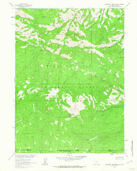
1961 Map of Blackhall Mountain
USGS Topo · Published 1963About this map
Blackhall Mountain and Wood Mountain dominate the high-altitude terrain along the border of Wyoming and Colorado during this early 1960s survey. This portion of the Medicine Bow National Forest and Routt National Forest is defined by a complex drainage network, where the East Fork Encampment River and various branches of Big Creek, such as North Fork Big Creek and Middle Fork Big Creek, carve through the landscape. Evidence of early resource extraction and communication is present via a solitary Mine and an extensive Telephone Line that traverses the northern slopes. The map captures the infrastructure of the backcountry, from a network of Pack Trails and Jeep Trails to named watercourses like Beaver Creek and McAnulty Creek. The presence of the State Line between Carbon and Jackson Counties marks the administrative divide in this high-country wilderness.
Find a feature on this map
28 named features on this map. Tap any name to fly to it.
Don’t see what you’re looking for? This feature index may not catch every label — zoom into the map to look around manually.
Map Details
Editions of this 1961 Blackhall Mountain Map
4 editions found
Other maps of this area

1911 · Hahns Peak
USGS Topo · 1:125,000

1913 · Hahns Peak
USGS Topo · 1:125,000

1939 · Saratoga
USGS Topo · 1:125,000

1954 · Rawlins
USGS Topo · 1:250,000

1954 · Craig
USGS Topo · 1:250,000

1955 · Davis Peak
USGS Topo · 1:24,000

1955 · Pearl
USGS Topo · 1:24,000

1956 · Pearl
USGS Topo · 1:62,500

1957 · Craig
USGS Topo · 1:250,000

1958 · Rawlins
USGS Topo · 1:250,000