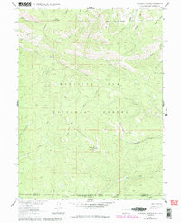
1961 Map of Blackhall Mountain
USGS Topo · Published 1984About this map
Blackhall Mountain stands as the central landmark of this high-altitude landscape along the border of the Medicine Bow National Forest and Routt National Forest. The map documents a rugged timberline environment where human intervention is limited to resource extraction and infrastructure. A mine is located on the slopes of Wood Mountain, while high-altitude water management is visible through the Telephone Ditch and Highline Ditch. These narrow waterways, along with the Pack Trail winding through the mountains, indicate the historical efforts to navigate and utilize this steep terrain. The survey also captures the VABM Lookout 10979 at the summit, a critical vantage point for forest management. This era's hydrology is defined by the headwaters of the East Fork Encampment River and various branches of Big Creek flowing across the Wyoming and Colorado state line.
Find a feature on this map
32 named features on this map. Tap any name to fly to it.
Don’t see what you’re looking for? This feature index may not catch every label — zoom into the map to look around manually.
Map Details
Editions of this 1961 Blackhall Mountain Map
4 editions found
Other maps of this area

1911 · Hahns Peak
USGS Topo · 1:125,000

1913 · Hahns Peak
USGS Topo · 1:125,000

1939 · Saratoga
USGS Topo · 1:125,000

1954 · Rawlins
USGS Topo · 1:250,000

1954 · Craig
USGS Topo · 1:250,000

1955 · Davis Peak
USGS Topo · 1:24,000

1955 · Pearl
USGS Topo · 1:24,000

1956 · Pearl
USGS Topo · 1:62,500

1957 · Craig
USGS Topo · 1:250,000

1958 · Rawlins
USGS Topo · 1:250,000