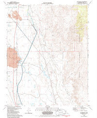
1982 Map of Blackrock
USGS Topo · Published 1985About this map
The Los Angeles Aqueduct and Old Railroad Grade define the transport and utility corridors of the Owens Valley in the early 1980s. This survey illustrates the intricate water management system surrounding the Blackrock Fish Hatchery, where Blackrock Springs, the Blackrock Ditch, and a series of bypasses navigate the valley floor. To the east, the terrain rises into the Inyo National Forest along Crystal Ridge, where the Black Jack Mine and Jack Black Mine suggest a history of prospecting in the foothills.
Find a feature on this map
33 named features on this map. Tap any name to fly to it.
Don’t see what you’re looking for? This feature index may not catch every label — zoom into the map to look around manually.
Map Details
Editions of this 1982 Blackrock Map
2 editions found
Other maps of this area

1907 · Mt. Whitney
USGS Topo · 1:125,000

1913 · Bishop
USGS Topo · 1:125,000

1919 · Mt. Whitney
USGS Topo · 1:125,000

1937 · Mt. Whitney
USGS Topo · 1:125,000

1947 · Mariposa
USGS Topo · 1:250,000

1948 · Fresno
USGS Topo · 1:250,000

1948 · Mariposa
USGS Topo · 1:250,000

1950 · Big Pine
USGS Topo · 1:62,500

1951 · Waucoba Mtn.
USGS Topo · 1:62,500

1951 · Independence
USGS Topo · 1:62,500