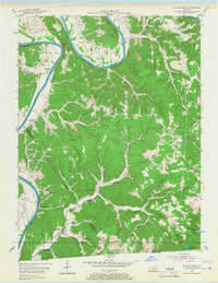
1954 Map of Blacks Ferry
USGS Topo · Published 1968About this map
The Cumberland River carves a dramatic series of oxbows through this landscape, including the sharp loops of Salt Lick Bend and Elbow Bend. This 1954 survey captures the agrarian character of Cumberland and Monroe Counties, where small rural hubs like Blacks Ferry, Martinsburg, and Peytonsburg serve as anchors for the surrounding ridge-and-hollow terrain. The map records a dense network of local schools and churches, such as Hickory Grove Ch and Coe Sch, which speak to the decentralized social structure of mid-century Kentucky. Along the southern border, the waters of the Dale Hollow Reservoir begin to submerge the valley floors at the state line. Notable for genealogists are the numerous family-named landmarks like Stalcup and Philpot Cem, alongside topographical features like The Narrows, where the river nearly loops back upon itself.
Find a feature on this map
65 named features on this map. Tap any name to fly to it.
Don’t see what you’re looking for? This feature index may not catch every label — zoom into the map to look around manually.
Map Details
Editions of this 1954 Blacks Ferry Map
3 editions found
Other maps of this area

1924 · Lillydale
USGS Topo · 1:62,500

1926 · Lillydale
USGS Topo · 1:62,500

1929 · Lillydale
USGS Topo · 1:62,500

1929 · Tompkinsville
USGS Topo · 1:62,500

1953 · Waterview
USGS Topo · 1:24,000

1953 · Burkesville
USGS Topo · 1:24,000

1953 · Dubre
USGS Topo · 1:24,000

1954 · Frogue
USGS Topo · 1:24,000

1954 · Blacks Ferry
USGS Topo · 1:24,000
1954 · Vernon
USGS Topo · 1:24,000