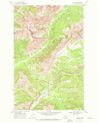
1968 Map of Blacktail
USGS Topo · Published 1971About this map
Glacier National Park and Flathead National Forest meet along the high spine of the Continental Divide in this late 1960s topographic study. The landscape is defined by the critical transportation corridor of the Theodore Roosevelt Stevens John Pass, where the Burlington Northern railroad winds through the canyon alongside Bear Creek. Evidence of the harsh alpine environment and the infrastructure required to manage it is visible in the series of snowsheds protecting the tracks and the presence of the Fielding Patrol Cabin and Fielding Guard Sta. To the north, the terrain rises toward Brave Dog Mountain and Sheep Mountain, while to the south, the Giefer Twentyfive Mile Creek Trail leads into the dense forest. This map documents a period when these mountain passes remained vital links for transcontinental rail traffic, even as they served as gateways for wilderness recreation.
Find a feature on this map
39 named features on this map. Tap any name to fly to it.
Don’t see what you’re looking for? This feature index may not catch every label — zoom into the map to look around manually.
Map Details
Editions of this 1968 Blacktail Map
2 editions found
Other maps of this area

1913 · Marias Pass
USGS Topo · 1:125,000

1914 · Nyack
USGS Topo · 1:125,000

1958 · Red Plume Mountain
USGS Topo · 1:24,000

1958 · Nimrod
USGS Topo · 1:24,000

1958 · Mount Bradley
USGS Topo · 1:24,000

1960 · Cut Bank
USGS Topo · 1:250,000

1963 · Cut Bank
USGS Topo · 1:250,000

1964 · Cut Bank
USGS Topo · 1:250,000

1964 · Essex
USGS Topo · 1:24,000
1964 · Mount Saint Nicholas
USGS Topo · 1:24,000