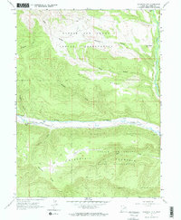
1962 Map of Blacktail Mtn
USGS Topo · Published 1970About this map
The Uintah and Ouray Indian Reservation covers the vast majority of this high-altitude landscape in Duchesne County, Utah, as documented by the Geological Survey during the late 1950s and early 1960s. The terrain is defined by dramatic elevation changes, with Blacktail Mountain and Blacktail Ridge rising above the deep incision of the Duchesne River. A primitive transportation network of several Jeep Trails threads through the ridges and hollows, including Seep Hollow and Dry Hollow, indicating a landscape largely used for resource management and ranching rather than dense settlement. Modern infrastructure is represented by a prominent Pipeline following the river valley and a Gaging Station monitoring the water flow. Distinctive landmarks like The Nipple and Sadies Flat offer local reference points within the complex topography of Mcafee Ridge, while Rock Creek provides a significant drainage point on the eastern edge of the quadrangle.
Find a feature on this map
17 named features on this map. Tap any name to fly to it.
Don’t see what you’re looking for? This feature index may not catch every label — zoom into the map to look around manually.
Map Details
Editions of this 1962 Blacktail Mtn Map
3 editions found
Other maps of this area

1885 · Uinta
USGS Topo · 1:250,000

1939 · Duchesne
USGS Topo · 1:125,000

1954 · Salt Lake City
USGS Topo · 1:250,000

1958 · Salt Lake City
USGS Topo · 1:250,000

1960 · Salt Lake City
USGS Topo · 1:250,000

1962 · Strawberry Pinnacles
USGS Topo · 1:24,000

1962 · Blacktail Mtn
USGS Topo · 1:24,000

1962 · Tabiona
USGS Topo · 1:24,000

1962 · Rabbit Gulch
USGS Topo · 1:24,000

1962 · Dry Mountain
USGS Topo · 1:24,000