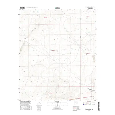
2017 Map of Blackwater Hill
USGS Topo · Published 2017About this map
Blackwater Hill rises as the central landmark of this New Mexico landscape, surrounded by a complex system of drainage channels and occasional catchment points. The topography is defined by the convergence of prominent natural features such as California Draw, Blackwater Draw, and Thirteenmile Draw in the southeast, reflecting a terrain shaped by episodic water flow in an arid environment. Near the northern boundary, small bodies of water like Little Lake and Christine Tank provide critical resources in this high-desert region, while Mare Lake sits further east. Transportation is minimal, focused around the corridor of Lake Spur Rd and the junction of Highway 70 380 in the southern portion of the quadrangle. This 2017 survey by the U.S. Geological Survey illustrates the intersection of vast ranching boundaries and the stark, natural geography of Chaves County.
Find a feature on this map
16 named features on this map. Tap any name to fly to it.
Don’t see what you’re looking for? This feature index may not catch every label — zoom into the map to look around manually.
Map Details
Editions of this 2017 Blackwater Hill Map
This is the sole edition of this map. No revisions or reprints were ever made.
Other maps of this area

1949 · Hondo Reservoir
USGS Topo · 1:24,000

1949 · Corn Ranch
USGS Topo · 1:24,000

1950 · Corn Ranch
USGS Topo · 1:24,000

1955 · Roswell
USGS Topo · 1:250,000

1956 · Diamond A Ranch
USGS Topo · 1:24,000

1958 · Roswell
USGS Topo · 1:250,000

1959 · Diamond A Ranch
USGS Topo · 1:24,000

1962 · Roswell
USGS Topo · 1:250,000

1962 · Horseshoe Bend
USGS Topo · 1:62,500
1963 · Barn Draw
USGS Topo · 1:24,000