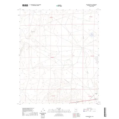
2023 Map of Blackwater Hill
USGS Topo · Published 2023About this map
Blackwater Hill rises as the primary landmark in this Chaves County landscape, overlooking a series of ephemeral water sources and drainage patterns essential to the region's ranching history. The presence of Christine Tank and small basins like Little Lake and Mare Lake reflect the critical importance of water management in this arid environment. Significant natural drainage systems including California Draw, Thirteenmile Draw, and Blackwater Draw cross the terrain, illustrating the hydrologic character of the plains. These features, along with early infrastructure such as Lake Spur Rd, provide a window into the land use and movement patterns of the area during the early twenty-first century.
Find a feature on this map
15 named features on this map. Tap any name to fly to it.
Don’t see what you’re looking for? This feature index may not catch every label — zoom into the map to look around manually.
Map Details
Editions of this 2023 Blackwater Hill Map
This is the sole edition of this map. No revisions or reprints were ever made.
Other maps of this area

1949 · Hondo Reservoir
USGS Topo · 1:24,000

1949 · Corn Ranch
USGS Topo · 1:24,000

1950 · Corn Ranch
USGS Topo · 1:24,000

1955 · Roswell
USGS Topo · 1:250,000

1956 · Diamond A Ranch
USGS Topo · 1:24,000

1958 · Roswell
USGS Topo · 1:250,000

1959 · Diamond A Ranch
USGS Topo · 1:24,000

1962 · Roswell
USGS Topo · 1:250,000

1962 · Horseshoe Bend
USGS Topo · 1:62,500
1963 · Barn Draw
USGS Topo · 1:24,000