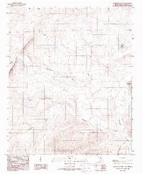
1988 Map of Blackwater Hill
USGS Topo · Published 1989About this map
Blackwater Hill dominates the western landscape of this Chaves County quadrangle, where the High Plains drop away toward the Pecos River valley. The terrain is defined by a series of significant drainage systems, including the long paths of Blackwater Draw and California Draw, which cut across the arid landscape. This 1980s survey illustrates the critical role of water management in eastern New Mexico, marking several isolated livestock watering points such as Christine Windmill, Bloom Windmill, and Border Well. These small-scale water sources, alongside larger catchments like Mare Lake and Mennecke Lake, were essential for ranching operations in a region where surface water is scarce. The map also records the transition from the upland heights down into Tecolote Canyon, providing a precise look at the topographical contours of the area during the late twentieth century.
Find a feature on this map
15 named features on this map. Tap any name to fly to it.
Don’t see what you’re looking for? This feature index may not catch every label — zoom into the map to look around manually.
Map Details
Editions of this 1988 Blackwater Hill Map
This is the sole edition of this map. No revisions or reprints were ever made.
Other maps of this area

1949 · Hondo Reservoir
USGS Topo · 1:24,000

1949 · Corn Ranch
USGS Topo · 1:24,000

1950 · Corn Ranch
USGS Topo · 1:24,000

1955 · Roswell
USGS Topo · 1:250,000

1956 · Diamond A Ranch
USGS Topo · 1:24,000

1958 · Roswell
USGS Topo · 1:250,000

1959 · Diamond A Ranch
USGS Topo · 1:24,000

1962 · Roswell
USGS Topo · 1:250,000

1962 · Horseshoe Bend
USGS Topo · 1:62,500
1963 · Barn Draw
USGS Topo · 1:24,000