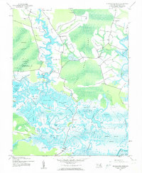
1942 Map of Blackwater River
USGS Topo · Published 1962About this map
Blackwater National Wildlife Refuge dominates this 1942 landscape, revealing a complex web of Maryland's eastern shore wetlands before modern environmental shifts. The terrain is a labyrinth of water and silt, where the Little Blackwater River and Blackwater River converge amidst vast expanses like Green Brier Swamp and Kentuck Swamp. Significant man-made alterations to the hydrology are visible through Keenes Ditch and Simons Ditch, which cut through the marshy interior. Small settlements and landings like Seward, Bucktown, and Robbins Landing provide evidence of a community deeply tied to the water. The presence of numerous named ponds, such as Harpers Pond and Wolfpit Pond, alongside Shorters Wharf, highlights a period when localized water access was essential for transport and commerce in Dorchester County.
Find a feature on this map
71 named features on this map. Tap any name to fly to it.
Don’t see what you’re looking for? This feature index may not catch every label — zoom into the map to look around manually.
Map Details
Editions of this 1942 Blackwater River Map
2 editions found
Other maps of this area

1898 · Choptank
USGS Topo · 1:125,000

1898 · St. Marys
USGS Topo · 1:125,000

1903 · Nanticoke
USGS Topo · 1:62,500

1904 · Oxford
USGS Topo · 1:62,500

1905 · Crapo
USGS Topo · 1:62,500

1905 · Hurlock
USGS Topo · 1:62,500

1906 · St. Marys
USGS Topo · 1:125,000

1908 · Choptank
USGS Topo · 1:125,000

1942 · Church Creek
USGS Topo · 1:24,000
1942 · Honga
USGS Topo · 1:24,000