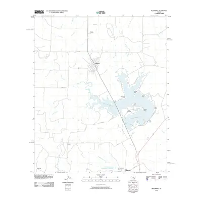
2010 Map of Blackwell
USGS Topo · Published 2010About this map
Blackwell serves as the primary settlement on this West Texas landscape, situated north of the expansive Oak Creek Reservoir. The terrain is defined by its water management and drainage systems, featuring the Oak Creek Dam and several points and peninsulas along the reservoir's shoreline, such as Hendry Point and Gulf Peninsula. To the south, the historic site of Fort Chadbourne sits near the Soil Conservation Service Site 4 Dam, marking a point of long-standing regional importance. For those researching local families, both the Blackwell Cemetery and Ross Cemetery are clearly marked. The map details a network of drainage basins, including Bouzier Creek and Middle Kickapoo Creek, which navigate the elevation changes near landmarks like Wiley Bluff and Coxs Gap.
Find a feature on this map
43 named features on this map. Tap any name to fly to it.
Don’t see what you’re looking for? This feature index may not catch every label — zoom into the map to look around manually.
Map Details
Editions of this 2010 Blackwell Map
This is the sole edition of this map. No revisions or reprints were ever made.
Other maps of this area

1891 · Hayrick
USGS Topo · 1:125,000

1893 · Sweetwater
USGS Topo · 1:125,000

1894 · Hayrick
USGS Topo · 1:125,000

1921 · Bronte
USGS Topo · 1:31,680

1954 · Big Spring
USGS Topo · 1:250,000

1954 · San Angelo
USGS Topo · 1:250,000

1958 · San Angelo
USGS Topo · 1:250,000

1958 · Big Spring
USGS Topo · 1:250,000
1961 · Hog Mountain
USGS Topo · 1:24,000
1961 · Bronte
USGS Topo · 1:24,000