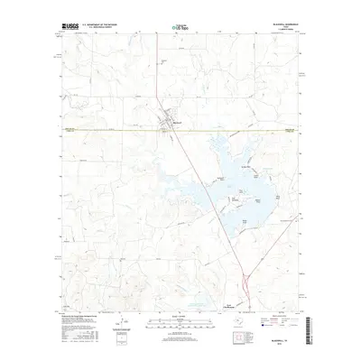
2016 Map of Blackwell
USGS Topo · Published 2016About this map
Blackwell serves as the primary hub in this West Texas landscape, where the town grid is defined by streets like Alamo Ave and E Railroad Ave along the county line between Nolan Co and Coke Co. The area’s geography is dominated by the expansive Oak Cr Reservoir, a major water body featuring numerous named points and landforms such as Gulf Peninsula, Humble Neck, and Wiley Bluff.
Find a feature on this map
63 named features on this map. Tap any name to fly to it.
Don’t see what you’re looking for? This feature index may not catch every label — zoom into the map to look around manually.
Map Details
Editions of this 2016 Blackwell Map
This is the sole edition of this map. No revisions or reprints were ever made.
Other maps of this area

1891 · Hayrick
USGS Topo · 1:125,000

1893 · Sweetwater
USGS Topo · 1:125,000

1894 · Hayrick
USGS Topo · 1:125,000

1921 · Bronte
USGS Topo · 1:31,680

1954 · Big Spring
USGS Topo · 1:250,000

1954 · San Angelo
USGS Topo · 1:250,000

1958 · San Angelo
USGS Topo · 1:250,000

1958 · Big Spring
USGS Topo · 1:250,000
1961 · Hog Mountain
USGS Topo · 1:24,000
1961 · Bronte
USGS Topo · 1:24,000