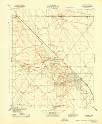
1943 Map of Blackwell
USGS Topo · Published 1943About this map
Antelope Plain dominates the landscape of western Kern County, where the infrastructure of the mid-century petroleum industry meets the arid California interior. This 1943 survey, prepared by the War Department and the Corps of Engineers, details the emergence of industrial centers like North Belridge and the surrounding oil fields. Strategic landmarks such as the Lost Hills High Derrick and the Belridge Oil Field Stack indicate a terrain heavily modified for extraction. Settlement is concentrated at key junctions like Blackwell's Corner along U.S. Route 33, while individual holdings such as C Twisselmann represent the rural residential presence in the region. The map also documents the critical water and power infrastructure supporting these remote operations, including the Middlewater Pump Station and various USC&GS triangulation points that served as essential survey benchmarks during this period of intensive development.
Find a feature on this map
14 named features on this map. Tap any name to fly to it.
Don’t see what you’re looking for? This feature index may not catch every label — zoom into the map to look around manually.
Map Details
Editions of this 1943 Blackwell Map
This is the sole edition of this map. No revisions or reprints were ever made.
Other maps of this area

1912 · McKittrick
USGS Topo · 1:125,000

1914 · Lost Hills
USGS Topo · 1:125,000

1932 · Antelope Plain
USGS Topo · 1:31,680

1932 · West of Goose Lake
USGS Topo · 1:31,680

1932 · Reynolds Ranch
USGS Topo · 1:31,680

1934 · West of Goose Lake
USGS Topo · 1:31,680
1936 · Antelope Plain
USGS Topo · 1:31,680
1940 · Reynolds Ranch
USGS Topo · 1:31,680
1942 · Hart Station
USGS Topo · 1:62,500

1943 · Simmler
USGS Topo · 1:62,500