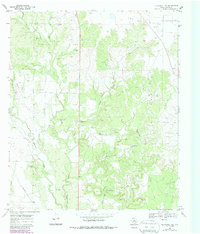
1969 Map of Blackwell NE
USGS Topo · Published 1987About this map
The Divide anchors the northern high ground of this landscape, marking a prominent relief feature in Nolan County. Below this crest, the terrain is defined by a network of drainage systems including Oak Creek, Pecan Creek, and Cottonwood Creek. The 1969 field survey reveals a land increasingly shaped by the energy industry, evidenced by numerous Oil Wells and a sprawling Oil Field to the south.
Find a feature on this map
20 named features on this map. Tap any name to fly to it.
Don’t see what you’re looking for? This feature index may not catch every label — zoom into the map to look around manually.
Map Details
Editions of this 1969 Blackwell NE Map
2 editions found
Other maps of this area

1893 · Sweetwater
USGS Topo · 1:125,000

1954 · Big Spring
USGS Topo · 1:250,000

1957 · Merkel
USGS Topo · 1:62,500

1958 · Big Spring
USGS Topo · 1:250,000

1967 · Hylton
USGS Topo · 1:24,000
1967 · Church Peak
USGS Topo · 1:24,000

1969 · Blackwell NE
USGS Topo · 1:24,000

1969 · Maryneal
USGS Topo · 1:24,000
1969 · Blackwell SW
USGS Topo · 1:24,000
1969 · Blackwell
USGS Topo · 1:24,000