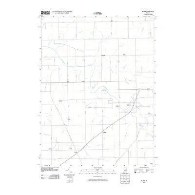
2010 Map of Blaine
USGS Topo · Published 2010About this map
Salamonie River meanders across this rural Jay County landscape, providing the primary drainage for a network of agricultural ditches including Walling Ditch and Sipe Ditch. Small, unincorporated settlements like Blaine, Greene, and Como anchor the southern portion of the area, while Kitt and Corkwell sit to the north. The map reveals a high density of family-named burial grounds, such as Whicker Cemetery and Stratton Cemetery, which are vital for genealogical research in this part of Indiana. The terrain is characterized by a precise grid of rural roads, including W Walnut Corner Rd and S Mount Pleasant Rd, connecting isolated farmsteads. Water features such as Elm Brook and Hearne Run break the regularity of the farmland, suggesting the original hydrology before the extensive ditching systems were established to support regional agriculture.
Find a feature on this map
63 named features on this map. Tap any name to fly to it.
Don’t see what you’re looking for? This feature index may not catch every label — zoom into the map to look around manually.
Map Details
Editions of this 2010 Blaine Map
This is the sole edition of this map. No revisions or reprints were ever made.
Other maps of this area

1911 · Berne
USGS Topo · 1:48,000

1915 · Fort Recovery
USGS Topo · 1:48,000

1918 · Fort Recovery
USGS Topo · 1:62,500

1953 · Muncie
USGS Topo · 1:250,000

1956 · Muncie
USGS Topo · 1:250,000

1960 · Pennville
USGS Topo · 1:24,000

1960 · Blaine
USGS Topo · 1:24,000
1960 · Portland
USGS Topo · 1:24,000

1960 · Ridgeville
USGS Topo · 1:24,000
1960 · Deerfield
USGS Topo · 1:24,000