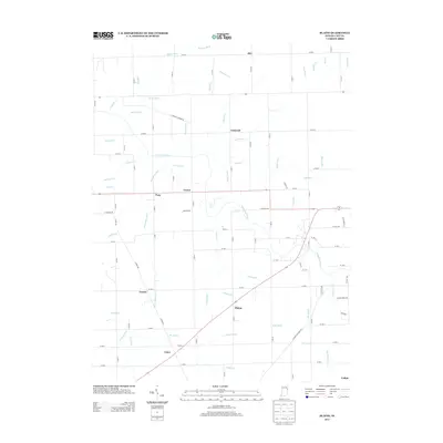
2013 Map of Blaine
USGS Topo · Published 2013About this map
The Salamonie River meanders across this rural Jay County landscape, defining the hydrology of a region heavily shaped by a network of drainage systems. Small agricultural settlements like Blaine, Pony, Como, and Greene are connected by a precise grid of county roads, reflecting the structured township-and-range development of eastern Indiana. The map reveals the extensive engineering required for local agriculture, featuring numerous named waterways such as Wikel Ditch, Cassell Ditch, and Blaine Run. These features illustrate how the natural flow of streams like Brooks Cr was augmented by hand-cut and machine-dug channels to manage the tillable land. This 2013 survey serves as a modern record of these longstanding crossroads communities and the persistent drainage infrastructure that has supported the area's farming heritage for generations.
Find a feature on this map
84 named features on this map. Tap any name to fly to it.
Don’t see what you’re looking for? This feature index may not catch every label — zoom into the map to look around manually.
Map Details
Editions of this 2013 Blaine Map
This is the sole edition of this map. No revisions or reprints were ever made.
Other maps of this area

1911 · Berne
USGS Topo · 1:48,000

1915 · Fort Recovery
USGS Topo · 1:48,000

1918 · Fort Recovery
USGS Topo · 1:62,500

1953 · Muncie
USGS Topo · 1:250,000

1956 · Muncie
USGS Topo · 1:250,000

1960 · Pennville
USGS Topo · 1:24,000

1960 · Blaine
USGS Topo · 1:24,000
1960 · Portland
USGS Topo · 1:24,000

1960 · Ridgeville
USGS Topo · 1:24,000
1960 · Deerfield
USGS Topo · 1:24,000