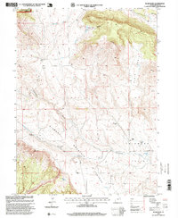
1996 Map of Blair Basin
USGS Topo · Published 1999About this map
Ashley National Forest dominates the upper reaches of this high-elevation landscape, where the rugged descent from the Diamond Mountain Plateau meets the expansive Diamond Valley. In the mid-1990s, this area of Uintah County remained defined by its ranching heritage, evidenced by the dispersed holdings of the Goodrich Ranch, Willis Ranch, and Carl Searle Ranch. The map captures a complex network of water management and natural drainages, from the Calder Ditch and Pot Creek in the north to the seasonal flows of Diamond Gulch and Willow Spring Draw. A distinctive industrial element is the Cow Pipeline, which traverses the high country north of the Blair Basin, indicating the remote infrastructure required to support agricultural operations and resource management in this arid Utah backcountry.
Find a feature on this map
22 named features on this map. Tap any name to fly to it.
Don’t see what you’re looking for? This feature index may not catch every label — zoom into the map to look around manually.
Map Details
Editions of this 1996 Blair Basin Map
This is the sole edition of this map. No revisions or reprints were ever made.
Other maps of this area

1885 · Ashley
USGS Topo · 1:250,000

1950 · Burnt Cabin Gorge
USGS Topo · 1:24,000

1950 · Blair Basin
USGS Topo · 1:24,000

1952 · Warren Draw
USGS Topo · 1:24,000

1954 · Vernal
USGS Topo · 1:250,000

1955 · Island Park
USGS Topo · 1:24,000

1958 · Vernal
USGS Topo · 1:250,000

1960 · Vernal
USGS Topo · 1:250,000
1965 · Donkey Flat
USGS Topo · 1:24,000
1966 · Jensen Ridge
USGS Topo · 1:24,000