
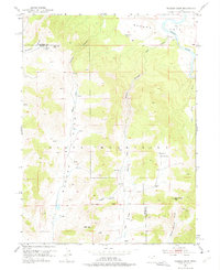
1952 Map of Warren Draw
USGS Topo · Published 1953About this map
The Green River flows through the northern reaches of this territory, passing the broad expanse of Browns Park and a vital Gaging Station. The landscape is defined by the high elevations of the Uinta Mountains, where significant passes like Dead Horse Pass and Felix Pass provided critical transit points across the high country during the mid-century. The map meticulously records the water sources essential for survival in this arid environment, including Spitzenberg Spring, Sears Spr, and several unnamed Springs. Deeply incised drainages such as Sears Canyon and Tolivers Canyon create a complex network of canyons that feed into the river system. To the south, the Salt Lake Base Line cuts across the terrain near Wagon Hollow and Mail Draw, serving as a foundational reference point for the region's early cadastral surveys.
Find a feature on this map
28 named features on this map. Tap any name to fly to it.
Don’t see what you’re looking for? This feature index may not catch every label — zoom into the map to look around manually.
Map Details
Editions of this 1952 Warren Draw Map
2 editions found
Other maps of this area

1885 · Ashley
USGS Topo · 1:250,000

1950 · Blair Basin
USGS Topo · 1:24,000

1952 · Willow Creek Butte
USGS Topo · 1:24,000

1952 · Swallow Canyon
USGS Topo · 1:24,000

1952 · Clay Basin
USGS Topo · 1:24,000

1952 · Goslin Mtn
USGS Topo · 1:24,000

1954 · Vernal
USGS Topo · 1:250,000

1958 · Vernal
USGS Topo · 1:250,000

1960 · Vernal
USGS Topo · 1:250,000
1967 · Hoy Mountain
USGS Topo · 1:24,000