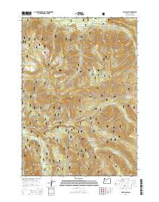
2014 Map of Blair Lake
USGS Topo · Published 2014About this map
Willamette National Forest encompasses this landscape of the Cascade Range, where high-elevation meadows and peaks define the topography of Lane County. The Mule Mtn Lookout stands as a central vantage point over a network of glacial lakes and creek systems, including the headwaters of the N Fork Middle Fork Willamette River. The map reveals a specific pattern of open alpine clearings known locally as prairies, such as Captain Prairie, Salt Rock Prairie, and Etta Prairie, which interrupt the dense timberlands. These features, alongside Blair Lake and Blair Meadows, illustrate the seasonal grazing and fire-lookout history of the Oregon Cascades. A complex web of forest development roads, including Nat For Dev Rd 19 and Natl Forest Develop Road 2424 Rd, provide the primary access to these remote ridgelines and water bodies like Devils Lake.
Find a feature on this map
46 named features on this map. Tap any name to fly to it.
Don’t see what you’re looking for? This feature index may not catch every label — zoom into the map to look around manually.
Map Details
Editions of this 2014 Blair Lake Map
This is the sole edition of this map. No revisions or reprints were ever made.
Other maps of this area

1925 · Waldo Lake
USGS Topo · 1:125,000

1955 · Chucksney Mtn
USGS Topo · 1:62,500

1956 · Waldo Lake
USGS Topo · 1:62,500

1956 · Oakridge
USGS Topo · 1:62,500

1956 · Sardine Butte
USGS Topo · 1:62,500

1958 · Roseburg
USGS Topo · 1:250,000

1959 · Roseburg
USGS Topo · 1:250,000

1983 · Oakridge
USGS Topo · 1:100,000
1986 · Mc Credie Springs
USGS Topo · 1:24,000
1986 · Blair Lake
USGS Topo · 1:24,000