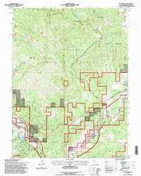
1994 Map of Blairsden
USGS Topo · Published 1998About this map
Blairsden and Graeagle anchor the southwestern corner of this landscape, situated within the Mohawk Valley where the Middle Fork Feather River winds through the terrain. The transition from valley floor to the high elevations of Plumas National Forest is marked by the Middle Fork Feather River Scenic Byway, which provides access to the small clusters of settlement at Delleker and Mable. Evidence of local industry appears in the Gravel Pits near the river and the Gaging Station used for monitoring water flow.
Find a feature on this map
42 named features on this map. Tap any name to fly to it.
Don’t see what you’re looking for? This feature index may not catch every label — zoom into the map to look around manually.
Map Details
Editions of this 1994 Blairsden Map
This is the sole edition of this map. No revisions or reprints were ever made.
Other maps of this area

1890 · Sierraville
USGS Topo · 1:125,000

1891 · Downieville
USGS Topo · 1:125,000

1892 · Sierraville
USGS Topo · 1:125,000

1893 · Downieville
USGS Topo · 1:125,000

1894 · Sierraville
USGS Topo · 1:125,000

1895 · Downieville
USGS Topo · 1:125,000

1896 · Downieville
USGS Topo · 1:125,000

1897 · Downieville
USGS Topo · 1:125,000

1937 · Blairsden
USGS Topo · 1:48,000

1943 · Blairsden
USGS Topo · 1:62,500