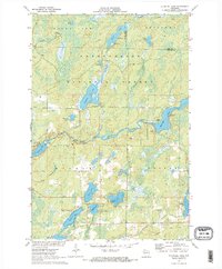
1971 Map of Blaisdell Lake
USGS Topo · Published 1973About this map
The East Fork Chippewa River meanders through a dense lacustrine landscape within the Chequamegon National Forest and the Winter Game Preserve. This 1971 survey illustrates a region defined by recreational and religious retreats, including the Wa-Ha-Kee Church Camp on Hunter Lake and Glenwood Camp on the northern shore of Blaisdell Lake. The infrastructure of the era is represented by a powerplant along the river and a dedicated Snowmobile Trail winding through the southern woods near the Brunet River. Numerous glacial lakes, such as Black Dan Lake, Fishtrap Lake, and Barber Lake, are depicted with significant detail, including depth curves and designated public access points. This record captures the Northwoods before modern development, showing a balance of timberland, water resources, and early outdoor tourism facilities.
Find a feature on this map
31 named features on this map. Tap any name to fly to it.
Don’t see what you’re looking for? This feature index may not catch every label — zoom into the map to look around manually.
Map Details
Editions of this 1971 Blaisdell Lake Map
2 editions found
Other maps of this area

1942 · Clam Lake
USGS Topo · 1:48,000

1943 · Namekagon Lake
USGS Topo · 1:48,000

1944 · Draper
USGS Topo · 1:48,000

1944 · Radisson
USGS Topo · 1:48,000

1945 · Namekagon Lake
USGS Topo · 1:48,000

1945 · Clam Lake
USGS Topo · 1:48,000

1947 · Draper
USGS Topo · 1:48,000

1949 · Radisson
USGS Topo · 1:48,000

1953 · Ashland
USGS Topo · 1:250,000

1953 · Rice Lake
USGS Topo · 1:250,000