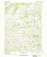
1968 Map of Blakesburg NE
USGS Topo · Published 1971About this map
The Chicago Milwaukee St Paul and Pacific railroad cuts across the northern edge of this landscape, anchoring the rural communities of Pleasant Home and Village. The terrain is defined by a dense network of drainage systems, including Soap Creek, Little Soap Creek, and Brush Creek, which carve through the townships of Adams, Center, and Greene. This 1960s survey captures a transition in the rural economy, where traditional gathering places like Mt Zion Ch and Hopewell Ch sit alongside modern infrastructure such as a prominent Radio Tower. Genealogists will find particular value in the documentation of several family and community burial sites, including Jay Cem and Hopewell Cem, located near the border of Wapello and Davis Counties.
Find a feature on this map
23 named features on this map. Tap any name to fly to it.
Don’t see what you’re looking for? This feature index may not catch every label — zoom into the map to look around manually.
Map Details
Editions of this 1968 Blakesburg NE Map
This is the sole edition of this map. No revisions or reprints were ever made.
Other maps of this area

1954 · Centerville
USGS Topo · 1:250,000

1954 · Des Moines
USGS Topo · 1:250,000

1956 · Des Moines
USGS Topo · 1:250,000

1956 · Ottumwa North
USGS Topo · 1:62,500

1956 · Ottumwa South
USGS Topo · 1:24,000

1956 · Ottumwa South
USGS Topo · 1:62,500

1956 · Ottumwa North
USGS Topo · 1:24,000

1957 · Des Moines
USGS Topo · 1:250,000

1957 · Centerville
USGS Topo · 1:250,000

1958 · Centerville
USGS Topo · 1:250,000