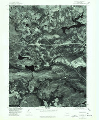
1976 Map of Blakeslee
USGS Topo · Published 1978About this map
Blakeslee and its surrounding mountain landscape appear here in a specialized orthophotograph produced in cooperation with the Soil Conservation Service. Unlike standard topographic line drawings, this 1976 image uses rectified aerial photography to reveal the actual footprint of residential development and forest cover in the Poconos. The intricate shoreline of Pocono Lake dominates the northeast, while the newer planned layout of Indian Mountain Lake is visible in the southeast. Large recreational developments at Split Rock and the intersection of major regional roads at Blakeslee provide a clear view of how this area was transitioning into a year-round vacation and residential hub during the mid-1970s. The photography captures the precise texture of the land, from the dense tree canopy to the cleared corridors for infrastructure and commerce.
Find a feature on this map
4 named features on this map. Tap any name to fly to it.
Don’t see what you’re looking for? This feature index may not catch every label — zoom into the map to look around manually.
Map Details
Editions of this 1976 Blakeslee Map
This is the sole edition of this map. No revisions or reprints were ever made.
Other maps of this area

1914 · Wind Gap
USGS Topo · 1:62,500

1916 · Wind Gap
USGS Topo · 1:62,500

1919 · Pocono
USGS Topo · 1:62,500

1921 · Pocono
USGS Topo · 1:62,500

1922 · Mauch Chunk
USGS Topo · 1:62,500

1922 · Stoddartsville
USGS Topo · 1:62,500

1923 · Pocono
USGS Topo · 1:62,500

1924 · Stoddartsville
USGS Topo · 1:62,500

1924 · Mauch Chunk
USGS Topo · 1:62,500

1943 · Scranton
USGS Topo · 1:125,000
Featured Places
- Kidder Township, PA
- Pocono Pines, Tobyhanna Township
- Penn Forest Township, PA
- Tobyhanna Township, PA
- Tunkhannock Township, PA