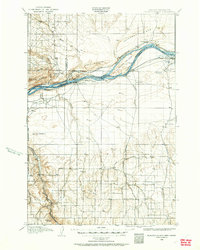
1906 Map of Blalock Island
USGS Topo · Published 1962About this map
The Columbia River serves as the dominant artery of this 1906 landscape, carving through a region defined by dramatic basalt ridges and developing rail infrastructure. Early riverfront settlements like Castle Rock and Paterson appear alongside the expansive Blalock Island, which sits in a reach of the river before modern hydroelectric projects altered the shoreline. To the south, the terrain transitions into a vast plateau of canyons and volcanic buttes, including Ella Butte and Dalreed Butte. Human activity is concentrated along the river corridor and the inland Willow Creek valley, where the towns of Cecil and Morgan are established along early travel routes. The presence of the Oregon-Washington Railroad and Navigation Co and the Spokane Portland and Seattle line highlights the era's transition from river-based transport to a robust rail economy connecting the interior to the coast.
Find a feature on this map
46 named features on this map. Tap any name to fly to it.
Don’t see what you’re looking for? This feature index may not catch every label — zoom into the map to look around manually.
Map Details
Editions of this 1906 Blalock Island Map
2 editions found
Other maps of this area

1906 · Blalock Island
USGS Topo · 1:125,000

1908 · Blalock Island
USGS Topo · 1:125,000

1908 · Umatilla
USGS Topo · 1:125,000

1910 · Zillah
USGS Topo · 1:125,000

1915 · Prosser
USGS Topo · 1:125,000

1916 · Arlington
USGS Topo · 1:125,000

1916 · Condon
USGS Topo · 1:125,000

1917 · Pasco
USGS Topo · 1:125,000

1917 · Prosser
USGS Topo · 1:125,000

1950 · Yakima
USGS Topo · 1:250,000