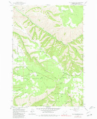
1963 Map of Blalock Mountain
USGS Topo · Published 1981About this map
The South Fork Walla Walla River carves a deep path through this section of the Umatilla National Forest, defining a landscape of high ridges and narrow canyons. Long before modern development reached these heights, the area served as a rugged corridor for early forest management and seasonal mountain activity. Notable landmarks like the Demaris Cabin and the Gaging Station on the river suggest a history of early habitation and resource monitoring in the Blue Mountains.
Find a feature on this map
44 named features on this map. Tap any name to fly to it.
Don’t see what you’re looking for? This feature index may not catch every label — zoom into the map to look around manually.
Map Details
Editions of this 1963 Blalock Mountain Map
3 editions found
Other maps of this area

1953 · Pendleton
USGS Topo · 1:250,000

1956 · Pendleton
USGS Topo · 1:250,000

1963 · Big Meadows
USGS Topo · 1:24,000

1963 · Andies Prairie
USGS Topo · 1:24,000

1963 · Bingham Springs
USGS Topo · 1:24,000

1963 · Tollgate
USGS Topo · 1:24,000

1963 · Blalock Mountain
USGS Topo · 1:24,000

1963 · Peterson Ridge
USGS Topo · 1:24,000

1964 · Bowlus Hill
USGS Topo · 1:24,000

1964 · Weston Mountain
USGS Topo · 1:24,000