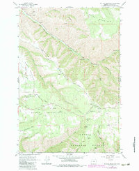
1963 Map of Blalock Mountain
USGS Topo · Published 1984About this map
The South Fork Walla Walla River carves a deep path through the northeast corner of the Umatilla National Forest, anchoring a landscape defined by sharp ridges and significant elevation changes. Historically, the area serves as a rugged backcountry resource, evidenced by the presence of the Demaris Cabin and remote outposts like Blue Mountain Camp and McDougall Camp. Transportation through this territory is largely confined to ridge-top routes such as the Lincton Mountain Road and Basket Mtn Road, which provide access between the high peaks of Blalock Mountain and Weston Mountain. Water sources are vital in this terrain, with numerous named points including Cold Spring, Dick Spring, and a Gaging Station monitoring the river's flow near the mouth of Flume Canyon.
Find a feature on this map
67 named features on this map. Tap any name to fly to it.
Don’t see what you’re looking for? This feature index may not catch every label — zoom into the map to look around manually.
Map Details
Editions of this 1963 Blalock Mountain Map
3 editions found
Other maps of this area

1953 · Pendleton
USGS Topo · 1:250,000

1956 · Pendleton
USGS Topo · 1:250,000

1963 · Big Meadows
USGS Topo · 1:24,000

1963 · Andies Prairie
USGS Topo · 1:24,000

1963 · Bingham Springs
USGS Topo · 1:24,000

1963 · Tollgate
USGS Topo · 1:24,000

1963 · Blalock Mountain
USGS Topo · 1:24,000

1963 · Peterson Ridge
USGS Topo · 1:24,000

1964 · Bowlus Hill
USGS Topo · 1:24,000

1964 · Weston Mountain
USGS Topo · 1:24,000