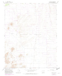
1965 Map of Blanca SE
USGS Topo · Published 1982About this map
San Luis Hills rise from the high desert floor in this mid-1960s study of Costilla County. The landscape is defined by its arid, geological character, where the prominent Sangre De Cristo and Basaltic Hills frame a territory shaped by water management and topographical markers. The presence of the Trinchera Canal and Trinchera Creek in the northern reaches indicates the critical role of irrigation and drainage in this portion of the San Luis Valley. This map, later updated in 1982, captures a sparse but structured environment where human activity is mostly limited to infrastructure like the Substa and various benchmark stations. For those studying the physical history of the valley, the detailed contour lines and landforms provide a precise look at the terrain before modern development shifted the agricultural and infrastructural footprint of the region.
Find a feature on this map
10 named features on this map. Tap any name to fly to it.
Don’t see what you’re looking for? This feature index may not catch every label — zoom into the map to look around manually.
Map Details
Editions of this 1965 Blanca SE Map
3 editions found
Other maps of this area

1954 · Trinidad
USGS Topo · 1:250,000

1955 · Trinidad
USGS Topo · 1:250,000

1958 · Trinidad
USGS Topo · 1:250,000

1959 · Trinidad
USGS Topo · 1:250,000

1965 · Blanca
USGS Topo · 1:24,000

1965 · Baldy
USGS Topo · 1:24,000

1965 · Lasauses
USGS Topo · 1:24,000

1965 · Blanca SE
USGS Topo · 1:24,000

1967 · San Luis
USGS Topo · 1:24,000

1967 · Fort Garland SW
USGS Topo · 1:24,000