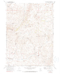
1968 Map of Blanchard Mtn
USGS Topo · Published 1980About this map
The Granite Range dominates this landscape in northeastern Elko County, centering on the high summit of Granite Peak and the surrounding high-altitude drainage systems. In the late 1960s, the area remained a hub for remote academic research and industrial exploration. The Knoll Creek Experimental Station stands out as a significant landmark for the University of Nevada, while a dense network of mining claims speaks to the region's mineral history. Numerous named prospects and mines, including the Hazel Mine, Arizona Mine, and Rosa O'Connell Mine, are scattered across the slopes near Blanchard Mtn. The terrain is deeply incised by drainages like Hanks Creek and Meadow Creek, where seasonal Springs and Jeep Trails provide the primary means of navigation through the high country between China Mountain and Knoll Mountain.
Find a feature on this map
46 named features on this map. Tap any name to fly to it.
Don’t see what you’re looking for? This feature index may not catch every label — zoom into the map to look around manually.
Map Details
Editions of this 1968 Blanchard Mtn Map
2 editions found
Other maps of this area

1955 · Wells
USGS Topo · 1:250,000

1957 · Contact
USGS Topo · 1:62,500

1957 · Delaplain
USGS Topo · 1:62,500

1958 · Wells
USGS Topo · 1:250,000

1961 · Wells
USGS Topo · 1:250,000

1968 · Knoll Mountain
USGS Topo · 1:24,000

1968 · Knoll Mountain SE
USGS Topo · 1:24,000

1968 · Henry
USGS Topo · 1:24,000

1968 · Blanchard Mtn
USGS Topo · 1:24,000

1968 · Texas Spring
USGS Topo · 1:24,000