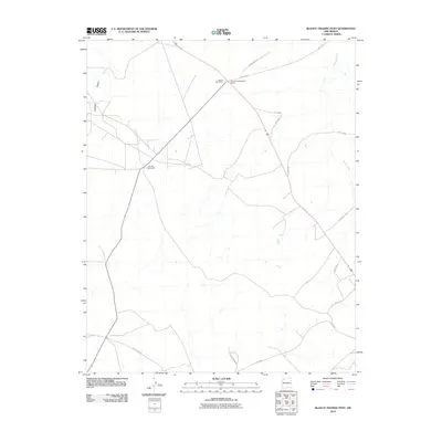
2010 Map of Blanco Trading Post
USGS Topo · Published 2010About this map
Pierres Archaeological District anchors the northern portion of this high-desert landscape in New Mexico, marking a site of deep cultural significance along the ancient routes of the Eastern Navajo Agency. This 2010 survey highlights the importance of historic commerce in the region, centered around the Blanco TradingPost and the Tsah Tah Trading Post. These hubs provided vital services to a sparse network of ranching and rural roads, such as Deer Springs Rd and County Rd 7675. The topography is defined by the significant drainage systems of Gallegos Canyon and Blanco Wash, which dictate the movement of both modern traffic and historical travel through this arid environment. The road network shown reflects the continued utility of established pathways that have connected the local communities for generations.
Find a feature on this map
16 named features on this map. Tap any name to fly to it.
Don’t see what you’re looking for? This feature index may not catch every label — zoom into the map to look around manually.
Map Details
Editions of this 2010 Blanco Trading Post Map
This is the sole edition of this map. No revisions or reprints were ever made.
Other maps of this area

1889 · Largo
USGS Topo · 1:250,000

1895 · Largo
USGS Topo · 1:250,000

1954 · Aztec
USGS Topo · 1:250,000

1958 · Aztec
USGS Topo · 1:250,000

1959 · Nageezi
USGS Topo · 1:62,500

1962 · Aztec
USGS Topo · 1:250,000

1965 · Aztec
USGS Topo · 1:250,000
1966 · Pueblo Bonito NW
USGS Topo · 1:24,000

1966 · Lybrook NW
USGS Topo · 1:24,000
1966 · Huerfano Trading Post SW
USGS Topo · 1:24,000