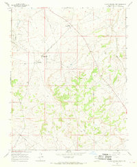
1966 Map of Blanco Trading Post
USGS Topo · Published 1969About this map
Blanco Trading Post serves as a primary geographic anchor in this San Juan County landscape during the mid-1960s. The map captures a high-desert environment defined by the dry watercourses of Gallegos Canyon and Blanco Wash, where infrastructure is sparse but specialized. Educational and religious outreach is represented by the Brethren in Christ Mission School, a notable landmark for regional historians and genealogists.
Find a feature on this map
16 named features on this map. Tap any name to fly to it.
Don’t see what you’re looking for? This feature index may not catch every label — zoom into the map to look around manually.
Map Details
Editions of this 1966 Blanco Trading Post Map
This is the sole edition of this map. No revisions or reprints were ever made.
Other maps of this area

1889 · Largo
USGS Topo · 1:250,000

1895 · Largo
USGS Topo · 1:250,000

1954 · Aztec
USGS Topo · 1:250,000

1958 · Aztec
USGS Topo · 1:250,000

1959 · Nageezi
USGS Topo · 1:62,500

1962 · Aztec
USGS Topo · 1:250,000

1965 · Aztec
USGS Topo · 1:250,000
1966 · Pueblo Bonito NW
USGS Topo · 1:24,000

1966 · Lybrook NW
USGS Topo · 1:24,000
1966 · Huerfano Trading Post SW
USGS Topo · 1:24,000