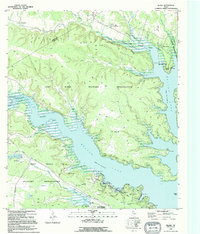
1995 Map of Bland
USGS Topo · Published 1995About this map
The Fort Hood Military Reservation dominates this landscape along the border of Coryell and Bell counties. By the mid-1990s, this area is defined by the expansive waters of Belton Lake, which submerged much of the former river valley. Despite the military's presence, civilian life and recreation persist around the lake's fingers, including the Liberty Hill Motocross Track and Camp Arrowhead Boy Scout Camp. Traditional rural anchors such as the County Line Community Center and the settlement of Cold Springs remain in the north, while the lake shore is heavily utilized for leisure at Temple Park and the Belton Lake Outdoor Recreation Area. The map illustrates a complex balance of tactical military training grounds and public outdoor space, with numerous 4WD trails winding through the Mountains and along the shores of Owl Creek.
Find a feature on this map
44 named features on this map. Tap any name to fly to it.
Don’t see what you’re looking for? This feature index may not catch every label — zoom into the map to look around manually.
Map Details
Editions of this 1995 Bland Map
This is the sole edition of this map. No revisions or reprints were ever made.
Other maps of this area

1892 · Temple
USGS Topo · 1:125,000

1894 · Gatesville
USGS Topo · 1:125,000

1924 · Gatesville 4-d
USGS Topo · 1:48,000

1924 · Gatesville 4-a
USGS Topo · 1:48,000

1924 · Temple 2-C
USGS Topo · 1:48,000

1924 · Temple 3-C
USGS Topo · 1:48,000

1924 · Temple 3-B
USGS Topo · 1:48,000

1930 · Killeen
USGS Topo · 1:62,500

1931 · Mc Gregor
USGS Topo · 1:62,500

1931 · Belton
USGS Topo · 1:62,500