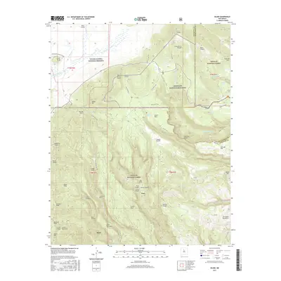
2017 Map of Bland
USGS Topo · Published 2017About this map
The settlement of Bland sits at the base of the Colle Jemez Canyon Mountains, surrounded by the high-elevation volcanic landscapes of the Jemez region. This area is defined by massive topographic features like the Valle Grande and the southern reaches of the Valles Caldera National Preserve. The map illustrates a complex network of canyons and ridges, including Capulin Canyon, Sanchez Canyon, and Obsidian Ridge, which serve as natural corridors through the volcanic plateau. Conservation and federal land management dominate the territory, with the boundaries of the Bandelier National Monument and the Santa Fe National Forest meeting in these highlands. Hikers and researchers can trace established routes such as the Valle Grande Trail and the E Ski Trail Loop, which navigate the steep terrain between Cerro Grande and the deeper valleys of the Rito de los Frijoles.
Find a feature on this map
62 named features on this map. Tap any name to fly to it.
Don’t see what you’re looking for? This feature index may not catch every label — zoom into the map to look around manually.
Map Details
Editions of this 2017 Bland Map
This is the sole edition of this map. No revisions or reprints were ever made.
Other maps of this area

1890 · Jemes
USGS Topo · 1:125,000

1892 · Jemes
USGS Topo · 1:125,000

1892 · Santa Clara
USGS Topo · 1:125,000

1937 · Jemez Springs
USGS Topo · 1:48,000

1943 · Jemez
USGS Topo · 1:62,500

1944 · Jemez Springs
USGS Topo · 1:62,500

1952 · Valle Toledo
USGS Topo · 1:24,000

1952 · Jemez Springs
USGS Topo · 1:62,500

1952 · Frijoles
USGS Topo · 1:24,000

1952 · Guaje Mountain
USGS Topo · 1:24,000