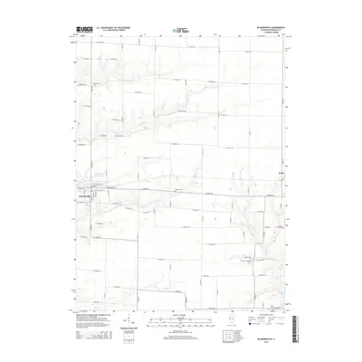
2015 Map of Blandinsville
USGS Topo · Published 2015About this map
Blandinsville serves as the primary hub of this Western Illinois landscape, situated at the junction of the Burlington Northern Santa Fe rail line and a grid of rural roads like W Main St. The surrounding countryside in McDonough County is defined by a dense network of family and community burial grounds, including Mustain Cem, Glade City Cem, and Pennington Number 1 Cem. These sites, often located near small watercourses like Little Cr or Baptist Cr, provide significant genealogical markers for the region. The map also captures the industrial and municipal infrastructure of the area, from the Blandinsville City Reservoir to the smaller settlement of Sciota on the eastern edge. Drainage follows the winding paths of the S Br La Moine River and La Harpe Cr, which carve through the agricultural fields that dominate the township.
Find a feature on this map
48 named features on this map. Tap any name to fly to it.
Don’t see what you’re looking for? This feature index may not catch every label — zoom into the map to look around manually.
Map Details
Editions of this 2015 Blandinsville Map
This is the sole edition of this map. No revisions or reprints were ever made.
Other maps of this area

1912 · Macomb
USGS Topo · 1:62,500

1913 · Colchester
USGS Topo · 1:62,500

1914 · Macomb
USGS Topo · 1:62,500

1916 · Good Hope
USGS Topo · 1:62,500

1918 · La Harpe
USGS Topo · 1:62,500

1918 · Good Hope
USGS Topo · 1:62,500

1958 · Burlington
USGS Topo · 1:250,000

1961 · Burlington
USGS Topo · 1:250,000

1963 · Burlington
USGS Topo · 1:250,000
1974 · Macomb
USGS Topo · 1:24,000