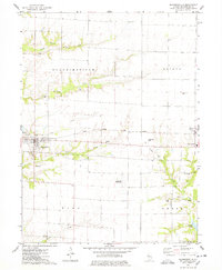
1974 Map of Blandinsville
USGS Topo · Published 1978About this map
The village of Blandinsville serves as the primary hub in this corner of McDonough County, surrounded by an organized grid of section lines and rural homesteads. The Toledo Peoria and Western railroad cuts a straight path across the prairie, linking the main settlement to the smaller community of Sciota and the Northwestern High Sch to the east. This landscape is defined by the transition from flat upland fields to the wooded drainages of the South Branch La Moine River and Baptist Creek. A notable specialized land use is the extensive Gas Storage Area south of Sciota, which occupies a significant portion of the subsurface rights in Hire and Emmet townships. For genealogists, the sheet is exceptionally detailed, noting numerous family and community burial grounds such as Liberty Cem, Anderson Cem, and Walker Cem.
Find a feature on this map
26 named features on this map. Tap any name to fly to it.
Don’t see what you’re looking for? This feature index may not catch every label — zoom into the map to look around manually.
Map Details
Editions of this 1974 Blandinsville Map
This is the sole edition of this map. No revisions or reprints were ever made.
Other maps of this area

1912 · Macomb
USGS Topo · 1:62,500

1913 · Colchester
USGS Topo · 1:62,500

1914 · Macomb
USGS Topo · 1:62,500

1916 · Good Hope
USGS Topo · 1:62,500

1918 · La Harpe
USGS Topo · 1:62,500

1918 · Good Hope
USGS Topo · 1:62,500

1958 · Burlington
USGS Topo · 1:250,000

1961 · Burlington
USGS Topo · 1:250,000

1963 · Burlington
USGS Topo · 1:250,000
1974 · Macomb
USGS Topo · 1:24,000