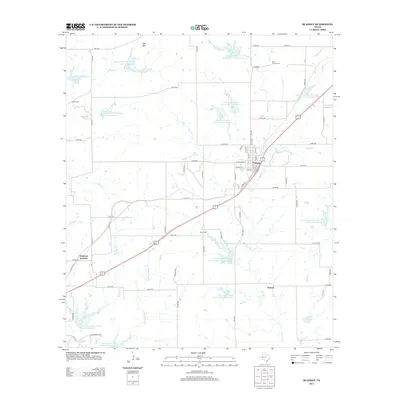
2012 Map of Blanket
USGS Topo · Published 2012About this map
The town of Blanket anchors this portion of Brown County, where a grid of rural roads and county routes connects small communities and agricultural lands. This 2012 study reveals a landscape heavily managed for water conservation, defined by a dense network of reservoirs including Soil Conservation Service Site 3 Reservoir and Soil Conservation Service Site 10 Reservoir. These sites manage the flow of local waterways like Blanket Creek and Salt Creek, which drain the area surrounding Salt Mountain. Genealogists and local historians can find several established burial grounds, such as Rock Church Cemetery and Routh Cemetery, situated at the periphery of the central settlement. The intersection of local transit and geography is further marked by Delaware Junction and the community of Antioch, reflecting the enduring settlement patterns of central Texas.
Find a feature on this map
77 named features on this map. Tap any name to fly to it.
Don’t see what you’re looking for? This feature index may not catch every label — zoom into the map to look around manually.
Map Details
Editions of this 2012 Blanket Map
This is the sole edition of this map. No revisions or reprints were ever made.
Other maps of this area

1889 · Brownwood
USGS Topo · 1:125,000

1894 · Brownwood
USGS Topo · 1:125,000

1925 · Brownwood 3-b
USGS Topo · 1:48,000

1928 · Zephyr
USGS Topo · 1:62,500

1931 · Mullin
USGS Topo · 1:62,500

1950 · Zephyr
USGS Topo · 1:62,500

1950 · Mullin
USGS Topo · 1:62,500

1954 · Brownwood
USGS Topo · 1:250,000
1966 · Owens
USGS Topo · 1:24,000
1966 · May
USGS Topo · 1:24,000