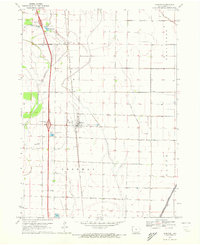
1970 Map of Blencoe
USGS Topo · Published 1972About this map
The town of Blencoe serves as the focal point for this 1970 survey, situated within a highly engineered drainage landscape of the Missouri River floodplain. This era of Monona County history is defined by a sophisticated network of canals designed to manage agricultural water flow, including the Mc Neil Outlet Ditch, Cleghorn Ditch, and Mc Candless Ditch. Transportation and commerce are anchored by the Chicago and North Western railroad corridor and the then-modern Interstate 29. Local heritage landmarks are clearly marked, such as Graceland Cem and the Creswell Landing Strip, alongside natural features like Guard Lake. The map illustrates the transition from traditional rail-based settlement patterns to the high-speed highway era while maintaining a strict grid of field lines and property boundaries across the townships of Franklin, Belvidere, Sherman, and Sioux.
Find a feature on this map
20 named features on this map. Tap any name to fly to it.
Don’t see what you’re looking for? This feature index may not catch every label — zoom into the map to look around manually.
Map Details
Editions of this 1970 Blencoe Map
This is the sole edition of this map. No revisions or reprints were ever made.
Other maps of this area

1954 · Omaha
USGS Topo · 1:250,000

1954 · Fort Dodge
USGS Topo · 1:250,000

1955 · Sioux City
USGS Topo · 1:250,000

1955 · Fremont
USGS Topo · 1:250,000

1957 · Fremont
USGS Topo · 1:250,000

1957 · Omaha
USGS Topo · 1:250,000

1957 · Fort Dodge
USGS Topo · 1:250,000

1958 · Sioux City
USGS Topo · 1:250,000

1958 · Omaha
USGS Topo · 1:250,000

1958 · Fremont
USGS Topo · 1:250,000