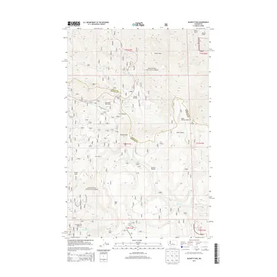
2014 Map of Blewett Pass
USGS Topo · Published 2014About this map
Wenatchee National Forest encompasses the high-altitude terrain of the Wenatchee Mountains, where the modern corridor of US Hwy 97 crosses the divide at Blewett Pass. This 2014 survey documents a landscape defined by sharp ridges and significant meadows, marking the boundary between Chelan and Kittitas counties. Distinctive geological landmarks like Diamond Head and Table Mtn anchor the southern portion of the sheet, while drainage networks such as Swauk Cr and Naneum Cr flow through deeply incised valleys. The map illustrates a dense concentration of mountain meadows, including Tronsen Meadow and Haney Meadow, which provide vital open spaces amidst the forested slopes. These meadows and the network of forest roads reflect the management of the land for conservation and recreation in the early 21st century.
Find a feature on this map
38 named features on this map. Tap any name to fly to it.
Don’t see what you’re looking for? This feature index may not catch every label — zoom into the map to look around manually.
Map Details
Editions of this 2014 Blewett Pass Map
This is the sole edition of this map. No revisions or reprints were ever made.
Other maps of this area

1897 · Mount Stuart
USGS Topo · 1:125,000

1902 · Mount Stuart
USGS Topo · 1:125,000

1913 · Wenatchee
USGS Topo · 1:62,500

1915 · Wenatchee
USGS Topo · 1:62,500

1920 · Colockum Pass
USGS Topo · 1:125,000

1922 · Colockum Pass
USGS Topo · 1:125,000

1957 · Wenatchee
USGS Topo · 1:250,000

1958 · Thorp
USGS Topo · 1:62,500

1961 · Liberty
USGS Topo · 1:62,500
1966 · Mission Peak
USGS Topo · 1:24,000