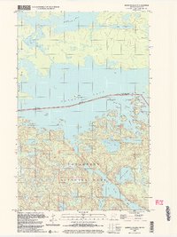
1999 Map of Blind Pig Island
USGS Topo · Published 2004About this map
Voyageurs National Park encompasses the southern portion of this borderland survey, where a labyrinth of islands and peninsulas defines the character of Namakan Lake. The international boundary between the Canada and United States follows the deep water of the lake, separating Ontario and Minnesota. This 1999 update reveals a landscape primarily managed for conservation and recreation, evidenced by numerous designated Campsites dotting the rocky shorelines of Blind Pig Island and the neighboring Hammer Bay. Internal waterways like Deep Slough and Blind Pig Channel provided essential navigation through the archipelago before modern roads. To the north, the terrain transitions into the Rainy River District, featuring smaller bodies of water such as Salo Lake and Kemp Lake, alongside the seasonal Winter Trail used for traversing the frozen interior.
Find a feature on this map
29 named features on this map. Tap any name to fly to it.
Don’t see what you’re looking for? This feature index may not catch every label — zoom into the map to look around manually.
Map Details
Editions of this 1999 Blind Pig Island Map
This is the sole edition of this map. No revisions or reprints were ever made.
Other maps of this area

1954 · International Falls
USGS Topo · 1:250,000

1957 · International Falls
USGS Topo · 1:250,000

1958 · International Falls
USGS Topo · 1:250,000

1963 · Redhorse Bay
USGS Topo · 1:24,000

1963 · Crane Lake
USGS Topo · 1:24,000

1967 · Namakan Island
USGS Topo · 1:24,000

1967 · Marion Lake
USGS Topo · 1:24,000

1967 · Hale Bay
USGS Topo · 1:24,000
1967 · Kettle Falls
USGS Topo · 1:24,000

1967 · Johnson Lake
USGS Topo · 1:24,000