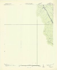
1936 Map of Block
USGS Topo · Published 1936About this map
Turley and the surrounding coal-country settlements of Hickey and Block occupy a narrow corridor of industrial development in this 1930s Tennessee Valley Authority and USGS collaboration. The landscape is defined by the steep slopes of Fork Mountain and Caryville Mountain, where the extractive economy of Campbell County is clearly visible through numerous inclines descending the ridges. The Southern railroad provides the primary artery for these mountain communities, running parallel to State Highway No. 63. A transition in the local industry is marked by a Mine (Abandoned) located south of Wheeler Gap, while the emerging modern infrastructure is represented by the Tepco Trans Line. This survey serves as a precise record of Tennessee's ridge-and-valley terrain before mid-century changes, documenting several elevation benchmarks and specific tract boundaries like T Tr 126 E.
Find a feature on this map
18 named features on this map. Tap any name to fly to it.
Don’t see what you’re looking for? This feature index may not catch every label — zoom into the map to look around manually.
Map Details
Editions of this 1936 Block Map
2 editions found
Other maps of this area

1893 · Briceville
USGS Topo · 1:125,000

1895 · Briceville
USGS Topo · 1:125,000

1896 · Briceville
USGS Topo · 1:125,000

1936 · Hogbell Gap
USGS Topo · 1:24,000

1936 · Ivydell
USGS Topo · 1:24,000

1936 · Block
USGS Topo · 1:24,000

1936 · Jacksboro
USGS Topo · 1:24,000

1936 · Pioneer
USGS Topo · 1:24,000

1936 · Duncan Flats
USGS Topo · 1:24,000

1936 · La Follette
USGS Topo · 1:48,000