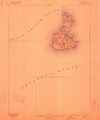
1899 Map of Block Island
USGS Topo · Published 1912About this map
New Shoreham stands at the heart of this island study, reflecting a maritime landscape shaped by late 19th-century navigation and local agriculture. The interior is marked by numerous fresh and salt water bodies including Sachem Pond, Great Salt Pond, and Sands Pond, which define the island's unique hydrography. The presence of several light stations and life-saving facilities, such as the Block Island S.E. L.H. and a L.S. Station, underscores the critical importance of this location to Atlantic shipping routes during this era. High points like Beacon Hill and Pilot Hill overlook a coastline defined by prominent markers such as Sandy Point and Black Rock Point, providing a detailed view of the island before modern coastal development altered these traditional maritime and farming boundaries.
Find a feature on this map
28 named features on this map. Tap any name to fly to it.
Don’t see what you’re looking for? This feature index may not catch every label — zoom into the map to look around manually.
Map Details
Editions of this 1899 Block Island Map
5 editions found
Other maps of this area

1889 · Stonington
USGS Topo · 1:62,500

1889 · Charlestown
USGS Topo · 1:62,500

1889 · Newport
USGS Topo · 1:62,500

1889 · Block Island
USGS Topo · 1:62,500

1893 · Stonington
USGS Topo · 1:62,500

1894 · Block Island
USGS Topo · 1:62,500

1894 · Newport
USGS Topo · 1:62,500

1899 · Block Island
USGS Topo · 1:62,500

1904 · Montauk
USGS Topo · 1:62,500

1904 · Newport
USGS Topo · 1:62,500