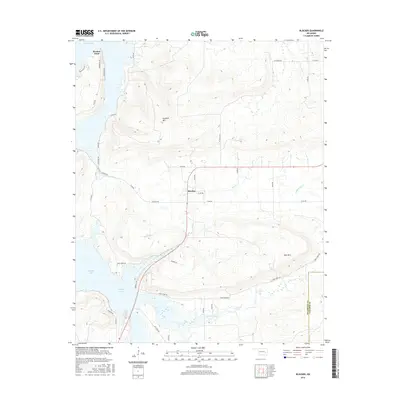
2016 Map of Blocker
USGS Topo · Published 2016About this map
Blocker sits at the heart of this landscape, positioned where the terrain transitions from the low-lying wetlands of Eufaula Lake to the more prominent elevations of the Oklahoma interior. The lake's irregular shoreline dominates the western edge of the quadrangle, with Bristow Point extending into the water near a network of local roads. Moving east, the topography rises toward notable high points such as Scaffold Mtn and Blue Mtn. This area is defined by its complex drainage system, including Mathuldy Cr, Blue Cr, and Jones Creek, which feed into the reservoir. The map reveals a rural infrastructure reliant on a dense grid of numbered roads like Blocker Rd and Jones Creek Rd, alongside the Pittsburg Co Latimer Co boundary line. The integration of established homestead access roads with the evolving shoreline of the lake illustrates the environmental and social character of this part of Pittsburg County.
Find a feature on this map
42 named features on this map. Tap any name to fly to it.
Don’t see what you’re looking for? This feature index may not catch every label — zoom into the map to look around manually.
Map Details
Editions of this 2016 Blocker Map
This is the sole edition of this map. No revisions or reprints were ever made.
Other maps of this area

1898 · McAlester
USGS Topo · 1:125,000

1900 · Sansbois
USGS Topo · 1:125,000

1900 · Canadian
USGS Topo · 1:125,000

1901 · Tuskahoma
USGS Topo · 1:125,000

1908 · Tuskahoma
USGS Topo · 1:125,000

1909 · Mc Alester
USGS Topo · 1:125,000

1909 · Tuskahoma
USGS Topo · 1:125,000

1909 · Sans Bois
USGS Topo · 1:125,000

1911 · Sansbois
USGS Topo · 1:125,000

1946 · Fort Smith
USGS Topo · 1:250,000