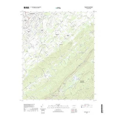
2019 Map of Blockhouse
USGS Topo · Published 2019About this map
Maryville and its southern suburbs occupy the northern reaches of this landscape, where residential growth meets the foothills of the Great Smoky Mountains National Park. The map reveals a dense network of local genealogy and community history, evidenced by numerous small burial grounds such as Magnolia Cem, Pecks Chapel Cem, and the Buchanan Family Cem. Moving south from the developed neighborhoods of Highland Acres and Heritage Hills, the terrain rises into the Black Sulphur Knobs and the prominent Chilhowee Mountain. This area is defined by the transition from city outskirts to the protected wilderness of the Gsmnp, following the winding path of the Foothills Parkway. Historic rural locations like Sixmile and Blockhouse are recorded alongside natural landmarks like White Oak Spring and Gold Mine Gap, documenting the enduring settlement patterns of Blount County.
Find a feature on this map
269 named features on this map. Tap any name to fly to it.
Don’t see what you’re looking for? This feature index may not catch every label — zoom into the map to look around manually.
Map Details
Editions of this 2019 Blockhouse Map
This is the sole edition of this map. No revisions or reprints were ever made.
Other maps of this area

1886 · Knoxville
USGS Topo · 1:125,000

1892 · Knoxville
USGS Topo · 1:125,000

1894 · Knoxville
USGS Topo · 1:125,000

1895 · Loudon
USGS Topo · 1:125,000

1895 · Knoxville
USGS Topo · 1:125,000

1901 · Knoxville
USGS Topo · 1:125,000

1935 · Binfield
USGS Topo · 1:24,000

1935 · Knoxville
USGS Topo · 1:48,000

1935 · Maryville
USGS Topo · 1:24,000

1935 · Wildwood
USGS Topo · 1:24,000