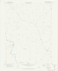
1969 Map of Blocksburg
USGS Topo · Published 1974About this map
Blocksburg serves as the primary hub of this 1960s landscape, situated along the Alderpoint Road as it winds through the interior mountains of Humboldt County. The settlement patterns reflect a rugged ranching and timber economy, evidenced by sites like Payton Ranch and various mountain hayfields. To the west, the Northwestern Pacific railroad tracks follow the winding course of the Eel River, passing through the small community of Oak Glen. This corridor highlights the critical role of rail transport in navigating the steep terrain and connecting these remote areas to broader markets.
Find a feature on this map
36 named features on this map. Tap any name to fly to it.
Don’t see what you’re looking for? This feature index may not catch every label — zoom into the map to look around manually.
Map Details
Editions of this 1969 Blocksburg Map
2 editions found
Other maps of this area

1920 · Harris
USGS Topo · 1:62,500

1921 · Dyerville
USGS Topo · 1:62,500

1921 · Briceland
USGS Topo · 1:62,500

1949 · Blocksburg
USGS Topo · 1:62,500

1949 · Alderpoint
USGS Topo · 1:62,500

1949 · Garberville
USGS Topo · 1:62,500

1949 · Weott
USGS Topo · 1:62,500

1951 · Alderpoint
USGS Topo · 1:62,500

1951 · Weott
USGS Topo · 1:62,500

1951 · Garberville
USGS Topo · 1:62,500