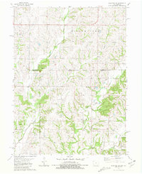
1981 Map of Blockton SE
USGS Topo · Published 1981About this map
The Middle Fork Grand River and East Fork Grand River converge in this borderland landscape, where the rural townships of Clinton and Fletchall meet at the state line. Surveyed in the late 1970s, the map reveals a network of country churches and family burial grounds that define the local social geography. Notable landmarks include Hickory Grove Ch and its namesake Hickory Grove Cem in the northeast, alongside Pleasant Hill Ch and Fletchall Ch.
Find a feature on this map
21 named features on this map. Tap any name to fly to it.
Don’t see what you’re looking for? This feature index may not catch every label — zoom into the map to look around manually.
Map Details
Editions of this 1981 Blockton SE Map
This is the sole edition of this map. No revisions or reprints were ever made.
Other maps of this area

1940 · Blockton
USGS Topo · 1:62,500

1942 · Grant City
USGS Topo · 1:62,500

1943 · Grant City
USGS Topo · 1:62,500

1943 · Blockton
USGS Topo · 1:62,500

1945 · Mount Ayr
USGS Topo · 1:62,500

1947 · Mount Ayr
USGS Topo · 1:62,500

1948 · Bethany
USGS Topo · 1:62,500

1955 · Nebraska City
USGS Topo · 1:250,000

1957 · Nebraska City
USGS Topo · 1:250,000

1958 · Nebraska City
USGS Topo · 1:250,000