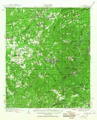
1934 Map of Blocton
USGS Topo · Published 1967About this map
Industrial mining operations and small agrarian settlements define this central Alabama landscape during the early 1930s. The coal-rich geology is anchored by Hill Creek Mines near the junction of the Southern Railway and Louisville and Nashville RR. These rail lines weave through the hills, connecting company towns and commercial hubs like West Blocton and Coleanor to the wider region. Beyond the industrial corridors, the map reveals a dense network of local landmarks, including Halls Mill on Shades Creek and rural gathering places like Schultz Creek Ch.
Find a feature on this map
87 named features on this map. Tap any name to fly to it.
Don’t see what you’re looking for? This feature index may not catch every label — zoom into the map to look around manually.
Map Details
Editions of this 1934 Blocton Map
3 editions found

Other maps of this area

1890 · Bessemer
USGS Topo · 1:125,000

1891 · Clanton
USGS Topo · 1:125,000

1892 · Bessemer
USGS Topo · 1:125,000

1899 · Brookwood
USGS Topo · 1:125,000

1905 · Bessemer Iron District
USGS Topo · 1:62,500

1907 · Bessemer Special
USGS Topo · 1:62,500

1910 · Montevallo
USGS Topo · 1:62,500

1927 · Adger
USGS Topo · 1:48,000

1929 · Searles
USGS Topo · 1:48,000

1931 · Cottondale
USGS Topo · 1:48,000