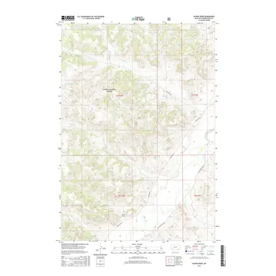
2017 Map of Bloom Creek
USGS Topo · Published 2017About this map
Custer National Forest encompasses a significant portion of this landscape, where the high plains of southeastern Montana are defined by a network of seasonal drainages and essential ranching water sources. The Powder River meanders through the southern reaches of the quadrangle, flanked by Dutch Gulch and fed by intermittent tributaries like Bloom Creek and Plum Creek. The topography is shaped by livestock agriculture and water management, evidenced by numerous named reservoirs including Rimrock Reservoir, Swope Reservoir, and Bull Reservoir. Critical transportation routes for this isolated ranching country, such as Moorehead Rd and Big Powder River E Rd, follow the natural contours of the river valley and ridges. These features, alongside Wolf Den Spring, illustrate a landscape where every water source is identified and significant for survival and industry.
Find a feature on this map
27 named features on this map. Tap any name to fly to it.
Don’t see what you’re looking for? This feature index may not catch every label — zoom into the map to look around manually.
Map Details
Editions of this 2017 Bloom Creek Map
This is the sole edition of this map. No revisions or reprints were ever made.
Other maps of this area

1954 · Ekalaka
USGS Topo · 1:250,000

1956 · Ekalaka
USGS Topo · 1:250,000

1958 · Ekalaka
USGS Topo · 1:250,000

1965 · Ekalaka
USGS Topo · 1:250,000

1966 · Phillips Butte
USGS Topo · 1:24,000

1966 · Hodsdon Flats
USGS Topo · 1:24,000

1970 · Moorhead
USGS Topo · 1:24,000

1970 · Bloom Creek
USGS Topo · 1:24,000

1970 · Huckins School
USGS Topo · 1:24,000
1970 · Sayle
USGS Topo · 1:24,000