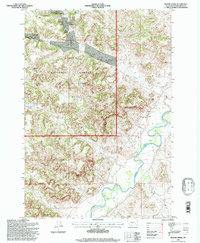
1995 Map of Bloom Creek
USGS Topo · Published 1998About this map
Custer National Forest defines the high-country landscape of this Powder River County map, showcasing the water management strategies utilized in the Montana ranching country during the late 20th century. The topography is marked by numerous man-made catchments, including Rimrock Reservoir, Bull Reservoir, and Swope Reservoir, which captured seasonal runoff to support livestock and land use. These features are dispersed across the drainages of Bloom Creek and Plum Creek, illustrating the vital connection between elevation and water access in the arid West.
Find a feature on this map
16 named features on this map. Tap any name to fly to it.
Don’t see what you’re looking for? This feature index may not catch every label — zoom into the map to look around manually.
Map Details
Editions of this 1995 Bloom Creek Map
This is the sole edition of this map. No revisions or reprints were ever made.
Other maps of this area

1954 · Ekalaka
USGS Topo · 1:250,000

1956 · Ekalaka
USGS Topo · 1:250,000

1958 · Ekalaka
USGS Topo · 1:250,000

1965 · Ekalaka
USGS Topo · 1:250,000

1966 · Phillips Butte
USGS Topo · 1:24,000

1966 · Hodsdon Flats
USGS Topo · 1:24,000

1970 · Moorhead
USGS Topo · 1:24,000

1970 · Bloom Creek
USGS Topo · 1:24,000

1970 · Huckins School
USGS Topo · 1:24,000
1970 · Sayle
USGS Topo · 1:24,000