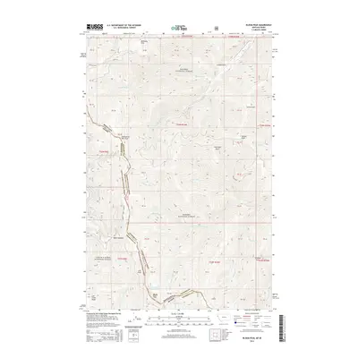
2014 Map of Bloom Peak
USGS Topo · Published 2014About this map
The Montana-Idaho state line forms the primary topographical spine of this 2014 survey, tracing the high ridges between Kanisku National Forest and Coeur d'Alene National Forest. This remote montane region is defined by a series of significant summits, including McNeeley Peak, Eightyseven Mile Peak, and the namesake Bloom Peak. The map illustrates a complex drainage system where steep gulches such as Jackson Gulch and Sorrel Gulch feed into numerous creeks, notably S Fork Marten Cr and W Fork Trout Cr. A singular high-altitude water feature, Ninetythree Mile Lake, sits just below the ridge line near the Sanders-Shoshone county boundary. The sparse road network, consisting largely of routes like NF RD 430, highlights the area's use for forest management and backcountry access along the Bitterroot Range.
Find a feature on this map
62 named features on this map. Tap any name to fly to it.
Don’t see what you’re looking for? This feature index may not catch every label — zoom into the map to look around manually.
Map Details
Editions of this 2014 Bloom Peak Map
This is the sole edition of this map. No revisions or reprints were ever made.
Other maps of this area

1932 · Trout Creek
USGS Topo · 1:125,000

1935 · Trout Creek
USGS Topo · 1:125,000

1936 · Trout Creek
USGS Topo · 1:125,000

1956 · Cooper Gulch
USGS Topo · 1:62,500

1956 · Wallace
USGS Topo · 1:250,000

1957 · Burke
USGS Topo · 1:62,500

1960 · Wallace
USGS Topo · 1:250,000
1966 · Noxon Rapids Dam
USGS Topo · 1:24,000
1966 · Taylor Peak
USGS Topo · 1:24,000
1966 · Bloom Peak
USGS Topo · 1:24,000