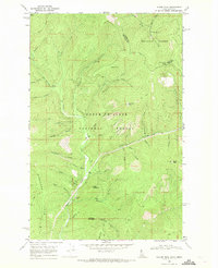
1966 Map of Taylor Peak
USGS Topo · Published 1971About this map
Kaniksu National Forest and Coeur d'Alene National Forest meet at the Idaho-Montana state line in this mid-1960s study of the Shoshone Range. The landscape is defined by an intricate network of drainages feeding into Shoshone Creek, including Monday Creek, Falls Creek, and Berlin Creek. The map documents a time when access to these high-elevation peaks was primarily restricted to a limited series of paths, such as the Pack Trail and Ridge Trail, reflecting the preservation of the back-country character.
Find a feature on this map
54 named features on this map. Tap any name to fly to it.
Don’t see what you’re looking for? This feature index may not catch every label — zoom into the map to look around manually.
Map Details
Editions of this 1966 Taylor Peak Map
This is the sole edition of this map. No revisions or reprints were ever made.
Other maps of this area

1909 · Cataldo
USGS Topo · 1:125,000

1911 · Cataldo
USGS Topo · 1:125,000

1932 · Trout Creek
USGS Topo · 1:125,000

1935 · Trout Creek
USGS Topo · 1:125,000

1936 · Trout Creek
USGS Topo · 1:125,000

1955 · Spokane
USGS Topo · 1:250,000

1956 · Wallace
USGS Topo · 1:250,000

1957 · Burke
USGS Topo · 1:62,500

1957 · Kellogg
USGS Topo · 1:62,500

1958 · Spokane
USGS Topo · 1:250,000